


A major, widespread winter storm will hammer the parts of the South, Midwest and Northeast Friday through Monday with potentially damaging ice and heavy snow for millions from New Mexico and Texas to parts of New England.
The storm has been named Winter Storm Fern by The Weather Channel.
Winter Storm Alerts
Winter storm watches have been issued from New Mexico into the Southeast.
Impacts are expected to be most severe in areas where winter storm warnings and ice storm warnings will eventually be issued. Pay attention to the timing of these alerts in The Weather Channel app.

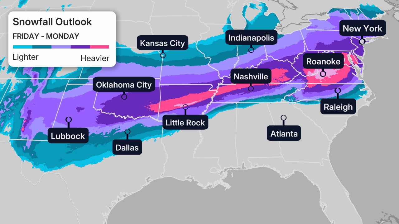
Timing And Cities Impacted
Friday:Snow, sleet and freezing rain will increase by late morning or early afternoon in the Plains, including parts of Kansas, Oklahoma and northern, western Texas to parts of Arkansas and possibly as far east as the Mid-South region of western Tennessee and northern Mississippi.
Cities:Lubbock, Oklahoma City, Tulsa, Little Rock

Friday night:This wintry mess of snow, sleet and ice will continue to sag southward in the Southern Plains and lower Mississippi Valley, and also spread east into parts of the Tennessee Valley, Appalachians as far east as parts of Virginia and the Carolinas.
Cities:Albuquerque, Oklahoma City, Tulsa, Dallas, Austin, Little Rock, Shreveport, Memphis, Nashville, Huntsville, Asheville

Saturday:Snow, sleet and ice could sink even a bit farther south in Texas, Louisiana and Mississippi, while it picks up in Kentucky, Tennessee, West Virginia, Virginia and parts of the Carolinas.
Cities:Albuquerque,Lubbock,Oklahoma City, Dallas, Austin, San Antonio(?), Little Rock, Shreveport, Memphis, Nashville, Knoxville, Asheville, Charlotte, Raleigh, Roanoke, Richmond

Saturday Night:This wintry mess may sag even farther south toward parts of southeast Texas, southwestern Louisiana, central Mississippi, northeast Georgia and South Carolina. Snow may spread into the mid-Atlantic states and intensify, while continuing farther west into the mid-Mississippi Valley, Ozarks, and parts of Oklahoma and Texas.
Cities:Houston, Dallas, Oklahoma City, Tulsa, Little Rock, Shreveport, Jackson, Memphis, Nashville, Knoxville, Charlotte, Greenville-Spartanburg, Columbia, Richmond, Washington, D.C., Baltimore, Pittsburgh, Philadelphia, New York City

Sunday:Wintry precipitation will end in Texas, Oklahoma and the lower Mississippi Valley by midday, but will persist from the Ohio Valley to the piedmont of Virginia and the Carolinas into the Northeast. Some areas of heavy snow are possible in parts of the Ohio Valley and Northeast.
Some snow and wind may persist in the Northeast Sunday night into Monday morning, before ending.
Cities: Houston, Shreveport, Jackson, Memphis, Nashville, Knoxville, Louisville, Cincinnati, Cleveland, Atlanta (northeast metro), Greenville-Spartanburg, Charlotte, Raleigh, Richmond, Washington, D.C., Baltimore, Pittsburgh, Philadelphia, New York City, Boston

How Much?
While there's uncertainty as to how persistent freezing rain will be in any one area during the storm, the map below shows where significant ice accumulations are forecast across a broad swath of the South, from parts of Texas to the Carolinas.
(The Range Of Ice Accumulation Forecast:The Best And Worst Scenarios)
In these areas, ice accumulations will be enough not only to make roads hazardous, if not impassable, but also to accumulate on trees and power lines, leading to tree damage and numerous power outages.
If you're in the areas contoured in the map below, you need to prepare for the potential of power outages, possibly lasting hours or a few days, especially considering cold air will plunge into the region during and after the storm.
(MORE:5 Things You Need To Know About Ice Storms)

It is too early to give specific numbers as our forecast continues to zero in on this storm.
However, a broad swath from northern Texas and Oklahoma to the mid-Atlantic states could pick up heavier snowfall accumulations from Friday through late Sunday.
This could lead to hazardous, dangerous travel conditions in these areas. Some roads in parts of the South and Appalachians could become impassable by this weekend.
The Setup
We have a perfect setup expected this weekend, which is why models are leaning that there will be widespread winter weather for the South.
There are two main factors that will be contributing to the setup.

The first is an Arctic High that will set up shop over the Great Lakes near the end of the week, which will bring cold air to much of the South.
We also have a storm system that will begin in the Southwest and will head east. Moisture lifting north ahead of the disturbance will cause the rainfall across the South that is expected this week.
With the Arctic High pumping in cold air, temperatures will plummet, creating conditions that could be just right for winter weather.
Check back with us frequently to see how your weekend could be impacted.
Rob Shackelford is a meteorologist and climate scientist at weather.com. He received his undergraduate and master's degrees from the University of Georgia studying meteorology and experimenting with alternative hurricane forecasting tools.


